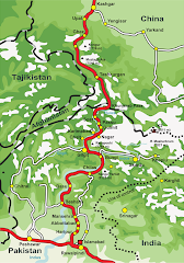
cultures

HUNZA GOJAL PICTURES

Thursday, February 11, 2010

Hunza Valley


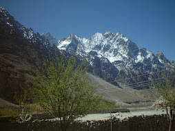
The Hunza Valley (Urdu: ہنزہ) is a mountainous valley in Gilgit in the Gilgit-Baltistan autonomous region, an area under the control of the government of Pakistan. The Hunza valley is situated to the north of the Hunza River, at an elevation of around 2,500 metres (8,200 ft). The territory of Hunza is about 7,900 square kilometres (3,100 sq mi). Karimabad (formerly called Baltit) is the main town, which is also a very popular tourist destination because of the spectacular scenery of the surrounding mountains like Ultar Sar, Rakaposhi, Bojahagur Duanasir II, Ghenta Peak, Hunza Peak, Diran Peak and Bublimating (Ladyfinger Peak), all 6,000 metres (19,685 ft) or higher.

Hunza was formerly a princely state bordering China to the north-east and Pamir to its north-west, which continued to survive until 1974, when it was finally dissolved by Zulfikar Ali Bhutto. The state bordered the Gilgit Agency to the south, the former princely state of Nagar to the east. The state capital was the town of Baltit (also known as Karimabad) and its old settlement is Ganish Village.

Hunza was an independent principality for more than 900 years. The British gained control of Hunza and the neighbouring valley of Nagar between 1889 and 1892 followed by a military engagement of severe intensity. The then Thom (Prince) Mir Safdar Ali Khan of Hunza fled toKashghar in China and sought what can be called political asylum.


First Muslim Thum

The ruling family of Hunza is called Ayeshe (heavenly), from the following circumstance. The two states of Hunza andNagar were formerly one, ruled by a branch of the Shahreis, the ruling family of Gilgit, whose seat of government was Nager. Tradition relates that Mayroo Khan, apparently the first Muslim Thum of Nagar some 200 years after the introduction of the religion of Islam to Gilgit, married a daughter of Trakhan of Gilgit, who bore him twin sons named Moghlot and Girkis. From the former the present ruling family of Nager is descended. The twins are said to have shown hostility to one another from birth. Their father seeing this and unable to settle the question of succession, divided his state between them, giving to Girkis the north, and to Moghlot the south, bank of the river. [1]


Thum

The traditional name for the ruler in Hunza was Thum, which is also a respectful appellation used by people of both Hunza and Nager who belong to the clan of Boorish. The Shin use the term Yeshkun for the Boorish.

Both Thums are still addressed as Soori, as a title of respect. This appears to be the same [in meaning] as Sri, an commonly prefixed to the names of Hindu princes in India, to denote their honour and prosperity. The Thum's wives are styled ghenish which is almost identical with the original Sanskrit word for mother, and their sons are called gushpoor.[2]


Geography

Baltit Fort, the former residence of the Mirs of Hunza

The Hunza is situated at an elevation of about 2,500 metres (8,200 ft). For many centuries, Hunza has provided the quickest access to Swat and Gandhara for a person travelling on foot. The route was impassable to baggage animals; only human porters could get through, and then only with permission from the locals.

Hunza was easily defended as the paths were often less than 0.5 metres (20 in) wide. The high mountain paths often crossed bare cliff faces on logs wedged into cracks in the cliff, with stones balanced on top. They were also constantly exposed to regular damage from weather and falling rocks. These were the much feared "hanging passageways" of the early Chinese histories that terrified all, including several famous Chinese Buddhist monks such as Xuanzang.


Climate

Spring in Hunza Valley

The temperature in May is a maximum of 27 °C (81 °F) and a minimum of 14 °C (57 °F); the October maximum is 10 °C (50 °F) and the minimum −10 °C (14.0 °F). Hunza's tourist season is generally from May to October, because in winter the Karakoram Highway is often blocked by the snow.

Transport

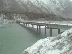
Today, the famous Karakoram Highway crosses Hunza, connecting Pakistan to China via the Khunjerab Pass. Travelling up the valley from the south, Hunza is the land to the left, and the former state of Nagar to the right of the Hunza River. Regular bus and van services operate between Gilgit and Central Hunza (Ganish Village, Aliabad and Karimabad) and also between Gilgit and Sost Gojal. PTDC Office at Gilgit, Sost and Islamabad arranges tours and transport for visitors.
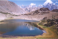

Spectacular scenery

Rakaposhi, 7,788 metres (25,551 ft)

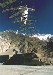
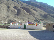
Hunza is one of the most impressive places in the world. Several high peaks rise above 6,000 metres (20,000 ft) in the surroundings of Hunza valley. The valley provides spectacular views of some of the most beautiful and magnificent mountains of the world which include Rakaposhi 7,788 metres (25,551 ft), Ultar Sar 7,388 metres (24,239 ft), Bojahagur Duanasir II7,329 metres (24,045 ft), Ghenta Sar 7,090 metres (23,261 ft), Hunza Peak 6,270 metres (20,571 ft),Darmyani Peak 6,090 metres (19,980 ft), and Bublimating (Ladyfinger Peak) 6,000 metres (19,685 ft). Hunza Valley is also host to the ancient watch towers in Ganish , Baltit Fort and Altit Fort. Watch towers are located in heart of Ganish Village, Baltit Fort stands on top of Karimabad whereas Altit Fortlies at the bottom of the valley.

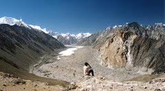
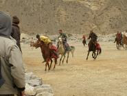
The valley is popularly believed to be the inspiration for the mythical valley of Shangri-la in James Hilton's 1933 novel Lost Horizon. As one travels up on the Karakoram Highway, the beautiful sceneries keep on revealing themselves. On the way one can witness the 65 kilometres (40 mi) long 'Batura' glacier, the second longest in Pakistan, surround by Shishper, Batura and Kumpirdior peaks. On reaching Sost one can continue the journey up to Khunzhrav or turn west to witness the mystic beauty of Chipursan (also Chapursan) valley. Chipursan valley has some of most exotic tourist spots in the area. In Yarzerech (also Yarzirich) you can have a look at the majestic Kundahill peak (6,000 metres (19,685 ft)), or trek along the Rishepzhurav to the Kundahill to experience the soothing sceneries. Beyond Yarzerech one can travel further to Lupghar, Raminj, Reshit, Yishkuk up to Bobo Ghundi (Oston), the shrine of Baba-e-Ghund, a saint from Afghanistan near the border between Pakistan and Wakhan region of Afghanistan.
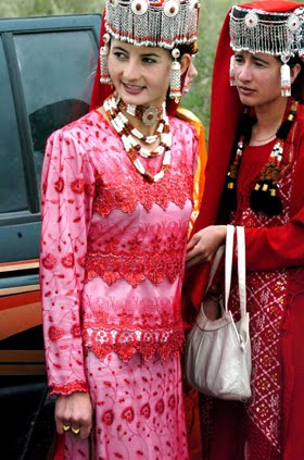

People of Hunza

Hunza valley river

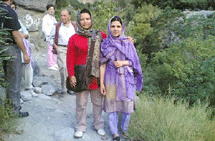
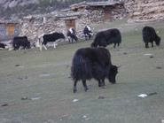
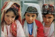
As much as the valley is famous for its beauty, the people of Hunza are noted for their friendliness and hospitality. The local languages spoken are Burushaski, Wakhi and Shina, many people understandUrdu. The literacy rate of the Hunza valley is believed to be more than 90%. Virtually every child of the new generation studies up to at least high school level. Many pursue higher studies from prestigious colleges and Universities of Pakistan and abroad.

Most of the people of Hunza are Ismaili Shia Muslims, followers of His Highness Prince Karim Aga Khan IV, while in Ganish Village more than 90% are Shia Muslims.

The Hunza region is home to people of three ethnicities:

The majority of the people are Ismaili Shia Muslims who are followers of the Aga Khan. The present Aga Khan IV has provided a lot of funding for the area to help with agriculture and the local economy through the Aga Khan Development Network.


New District

Hunza-Nagar became a new district in Gilgit-Baltistan starting in July, 2009. There is planned to be a Northern Areas Legislative CouncilAssembly (NALA) seat for Hunza.[3]


See also

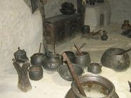
The Hunza valley contains many small villages. The first village is Khizerabad. Prior to the early 20th century, the people of the Hunza valley are said to have had an average lifespan of 100.[citation needed] This group of people were highly associated with nature, especially regarding dieting habits and lifestyle. They highly acknowledged the apricot seed, using it as currency. The women would squeeze out the liquid of the seeds, and spread it over their foreheads, eliminating their wrinkles even at an extraordinary age. Unfortunately with more contact to the outside world, the Hunzus' average lifespan increasingly dropped, due to different ideas and lifestyle their group was obtaining from other peoples. The Hunzu valley is frequently referred to as Shangri La, and is also known as "The Valley Where you Live Forever"


References

  1. ^ Tribes of the Hindoo Koosh by John Bidulph page 26
  2. ^ Tribes of the Hindoo Koosh by John Bidulph Sang e meel publication page 30
  3. ^ [1] HunzaTimes, June 24, 2009.
  • Kreutzmann, Hermann, Karakoram in Transition: Culture, Development , and Ecology in the Hunza Valley, Oxford University Press, 2006. ISBN 9780195472103
  • Leitner, G. W. (1893): Dardistan in 1866, 1886 and 1893: Being An Account of the History, Religions, Customs, Legends, Fables and Songs of Gilgit, Chilas, Kandia (Gabrial) Yasin, Chitral, Hunza, Nagyr and other parts of the Hindukush, as also a supplement to the second edition of The Hunza and Nagyr Handbook. And An Epitome of Part III of the author’s “The Languages and Races of Dardistan.”First Reprint 1978. Manjusri Publishing House, New Delhi.
  • Lorimer, Lt. Col. D.L.R. Folk Tales of Hunza. 1st edition 1935, Oslo. Three volumes. Vol. II, republished by the Institute of Folk Heritage, Islamabad. 1981.
  • Sidkey, M. H. "Shamans and Mountain Spirits in Hunza." Asian Foklore Studies, Vol. 53, No. 1 (1994), pp. 67–96.
  • History of Ancient Era Hunza State By Haji Qudratullah Beg English Translation By Lt Col (Rtd) Saadullah Beg, TI(M)


External links


Gojal Upper Hunza

Gojal, also known as Upper Hunza, is an area north of Gilgit in the far north of Pakistan near the Chinese and Afghan borders. It is the largesttehsil of the Northern Areas.

Gojal is a series of small and large valleys sharing borders with Hunza in the south, China in the north and east, and Afghanistan in the north-west. Shishkat is the first village of Gojal. Except for the Shimshal, Misgar and Chipursan valleys, all the villages of Gojal can be seen from the Karakorum Highway (KKH), which crosses Gojal, entering China at the Khunjerab Pass.

The population of Gojal is about 20,000. The majority speak the Wakhi language, while the Burushaski and Domaaki languages are also spoken in some villages. The people belong to the Ismaili sect of Shia Islam.
Population

.

Immigrants to Gojal originated from the Wakhan in Afghanistan, parts of China (like Ruskum), Tashkurgan and the Hunza valley.

Historically the people were shepherds and/or small-scale farmers. Over time, service industries have taken the lead and now most of the people are employed in government and non-governmental organizations. A significant number of the locals are also engaged in trade.

Literacy rates are very high throughout the region. The BBC reported thatPassu, a village on the KKH, had one hundred per cent literacy rate in 1998[citation needed]. Residents of remote valleys like Chipursan (bordering Wakhan, Afghanistan) and Shimshal (bordering China) have schools.


History

The different valleys and villages of Gojal were settled at different times by people from different surrounding regions. In the opinion of most researchers[citation needed], Kirghiz nomads initially used the areas in upper Gojal as winter pastures. It is said[by whom?] that later on whenWakhies migrated from Wakhan to this region, the Kirghiz nomads left. It is very difficult to determine when the Wakhies settled in Gojal. However, it is narrated[by whom?] that the earlier Wakhi migrated from Wakhan and settled in the Yishkuk (Chipursun) valley and later theBoiber areas. It is also narrated[by whom?] that when Hunza was under the Central Government of Gilgit the Ishkook settlement was very wealthy and regularly paying tax in terms of cattle and other dairy products to the Raja of Gilgit. As Hunza emerged as an independent stateduring the early 15th century so it can be inferred that different valleys in upper Gojal were inhabited by the Wakhi speaking migrants even before emergence of the Hunza state. Later, the oral history holds, a catastrophic flood destroyed the Ishkook settlement during 18th century.


Settlement of Passu

Passu was first inhabited by "Quli" from [Wakhan]. According to local elders, the old Passu was once home to some 300 households. Due to Shimshal's flood and continuous erosion from river side the old Passu settlement was destroyed, forcing the population to leave and to migrate back to their places of origin in central Asia. Later, Passu was resettled by a man named Quli, who is today generally recognized as the ancestor of the majority of Passu’s population. Due to this reference the people of Passu is still called Quli-kuts/kutor. People of Quli-kuts (tribe) origin, also inhabit Karimabad, Murtazaabad and many other villages of central Hunza. The Quli-kuts in central Hunza later adopted the Burushu way of life and now speak Burushaski language.

According to Archeologists, Human’s era passes generation to generation. Passu village is devastated four times in the past. Its first era of human generation is included 3000bc to 5000bc. there you can see many arts of ibex and zebra in different rocks. It shows that people are started to live here so early.After a few decades this village had destroyed by flood, sliding and erodes of rivers. That’s why this village had been empty for a long time. Its second era was pretty historical coz Chinese people lived here, who followed Buddha. Buddha religion came through Gandahara, Swat, Gilgit, Passu and reached China . Its great memory is at karga Gilgit and khuram Abad Passu. Its third era is called Islamic coz there is QURANI AYAT written on the mountain. Islam came here in 9th century through Arabs soldiers when Buddha left. Its fourth era also called Islamic, which had been started from 18th century at the time there were 315 families. During sliding the river was blocked and again this village was destroyed by natural disaster. This time only few families were safe. Later on, again this village was destroyed by natural disaster in 1964. Most of the families were migrated to chapurson and Khyber. Now seven families are recently living which are Magvi Dinali, Sakhi, Alvi , Quba, and Hadab, the population is around 1000.


Settlement of Ghulkin

There is no accurate historical record of the origin of the village, though it is estimated to be around 600 years old. According to local folklore, there were settlements here while the lake was still in existence, this area being used as pastureland in summer. The name is derived from two words of the local Wakhi dialect, 'Ghulk', meaning 'well' and 'kin', meaning 'whose'. Being an area of low rainfall, the most vital requirement is water for irrigation, livestock, drinking and domestic use. Khawaja Ahmed, and Ismaili Muslim who came here with the Mir of Hunza, asked him for land. After the Mir agreed, Khawaja Ahmed mobilised the people of the area to construct a water-channel to irrigate the land. This made cultivation possible and the Ismaili settlement flourished. Now small scale health and educational institutions, electricity and water-sully facilities are available in the village. Through the involvement of capacity-building NGOs, there is also a handicraft production centre and opportunities for other vocational training. The Jammatkhana, the central religious institution for all Ismaili Muslims, holds a strong position in the community. Apart from its religious functions, it provides a central location for community meetings, festivals, celebrations, resolution of disputes and much more. In Upper Hunza, winters are long and can become bitterly cold. Snowfall brings with it the Himalayian ibex, descending in search for grass breaking through the covering snow. Summers are hot in the north, though more pleasant than the harsh temperatures in summer are around 30 degrees Celsius. In winter the temperature remains below freezing point, further dropping at night


Most recent settlers

The last settlements in Gojal occurred during the reign of Mir Nazim Khan (1892-1931). During this period The barren lands in Shishket was settled with Burushu from Central Hunza in 1903. Shishket is thus also called as Nazimabad I. During same period the barren lands in Upper Sost was also inhibited by the people from Central Hunza which is called Nazimabad II. Raminj was also settled down during his reign.


Geography

Geographically Gojal is located between 70 latitude and 61 and is spread over an area of 8,500 km² of land, at an elevation ranging from 2,340m to 4,877m, above the sea level.

Gojal is a mountainous region forming the western part of the Karakoram and Eastern Pamir mountain range. This area also hosts the 56 km long Batura glacier the fourth longest of Pakistan (after Siachin, Hispar and Biafo).

The region is home to lofty ice capped peaks, roaring rivers, lush green pastures and long glaciers.


Villages

Main villages include: Shishket (now Nazeemabad), Gulmit, Ghulkin, Hussaini(older names Sisoni/Ghusani), Borith, Passu, Shimshal,Khyber, Ghalapan, Morkhoon, Jamalabad, Gircha, Sartiz, Sost, Khudaabad, Misgar, Yarzerech, Raminj, Kirmin, Reshit Khill, Shersabz, Ispenj, Shitmerg and Zoodkhoon.


Language and education

Wakhi and Burushaski are the languages of Gojal. The Wakhi language has come from Wakhan Pamir, and Burshaski is the language of Hunza. 80% of the population speak Wakhi, and 20% speak Burushaski. The Wakhi language is written in Roman script, and Burushaki is written in Arabic. Education literacy rate is very high in every village of Gojal, for both males and females. It is the great achievement of Aga Khan Education Service who has played the main role in promoting the standard education in the region.


Administration

Gulmit, the winter-capital of the then Hunza state until 1974, is the main town (Tehsil Head Quarters) and seat of government, while Sost is the border check-post and gateway for Pakistan-China overland trade. The entire region is governed by Pakistani bureaucrats, sitting inGilgit. Law and order is supported by two police stations and a magistrate.


Tourist Sites

Passu Valley

Passu is famous because it is home of the Batura Glacier and Passu Glacier. Adding more to the beauty of Passu, standing at the Northern end of the village, is Mount Tupopdon. Inspired by its unique structural attributes tourists have promoted the peak by giving it new names. Some call it "Passu Cones" and others "Passu Cathedral". Mount Tupopdon is the most photographed peak of the region. It is a village of nine Colors Mountains surrounding in its unique images. It has a unique place on the World map. With a rich history and deep rooted culture.

Fascinating land with an amazing diversity of places, people and customs, Passu is the mixing bowl of ancient civilization and dream of nature lovers, is well known about its extraordinary contrast of landscapes of the world. Passu is one of the most beautiful village of Pakistan . From times, immemorial the village has been promising Mountainous resort. Situated in the spectacular karakoram Mountains on the old silk route 150 km from Gilgit in the west banks of Hunza River and border on China . It has a unique place on the World map. With a rich history and deep rooted culture .It invites to its breath taking surrounding many adventurers, eco-tourist, historians and nature lovers. This famous village, its towering peaks ever flowing streams its fascinating heritage and above all its hospitable People make it a place worth visiting. Passu is considered the worlds heights landmass, where there is nothing below 2500 matters ,Passu is surrounded by some of the world most famous peaks, glaciers and lakes, such as Passu peak 7284, Shisper peak 7611, Batura, 7785, and the most remarkable is Passu cathedral peak 6500, in the shadow of lofty mountains are the Passu glacier with white skin and Batura glacier with both at the length of 56 km, which is the fifth largest glacier of the world.

Shimshal Valley ŠIMŠAL DIYOR

Disconnectivity from the modern world, until very recently, did not stop tourists. Every year thousands of mountain lovers visit Shimshal valley and see Mother Nature, exhibiting its colors, in a blend of Pamirian and Karakurumian aura. Shimshal, at one end, borders with thePeople's Republic of China and, on the other, is in close proximity of Kashmir (separated by Baltistan region). The Pamir pastures, lakes, Distgilsar Peak and other mystic peaks surround Shimshal valley, making it a potential dream treat for tourists from around the globe.

Chipursan Valley

Chipursan valley is a network of small and large villages close to the border of Afghanistan and parts of China. Historians say that this was the earliest human settlement of the entire region. Legends testify these claim but the valley remains a mystry for researchers and nature lovers. Chipursan is home to the Irshad Pass that connects Gojal Valley with Afghanistan. Also located in the vicinity of Chipursan Valley are Ishkoman, Buroghil and Yasin valleys.

Misgar Valley

Misgar valley is a narrow human settlement located very close to the Chinese border, almost parallel to Chipursan. Misgar is home to the Qalamdarchi Fort Fort of the Naked Saint. This "fort" was created by the British rulers of Hunza Valley to keep an eye on the movement of Soviet troops and spies in the region. Kilik and Mintika Passes adorn were used by traders, troops, travellers and, maybe, spies in the past. This fort is in a dilapidated condition. Parts of the fort are being used by Jawans of Pakistan Army.